Catchment Overview
Posted: January 19, 2014 Filed under: Uncategorized Leave a commentZoom, pan and set the Googlemap backdrop to the Pickering Beck fluvial vectors
“Slowing the Flow” :
The Pickering attenuation project was conceived following flooding and loss in 2007. Site-works are due to commence in 2013. The complementary approach outlined below is indicative of public interest to (respectfully) promote, potentially augment, and thereby extend attenuation solutions to other catchments.
The combined hydraulic effect of 40 ‘non-impounding’ buffer strips (in effect flow ‘speed-bumps’ – each no higher than 400mm but surmounted by wide dense porous stiff vegetation) is to be tested by synthetic Q40-Q80 events and analysed in two indicative 2D models. (See sketch and gallery).
The floodplain immediately upstream of urban (Pickering) value at risk is approximately 1km2. The beck falls 40m in 10km. Attenuation ridges (effectively land-use flow-controls spaced at approx 250m) grown in software between Pickering and Levisham station, could yield an increase in green temporary storage iro 500,000 m3 and diffuse (ie lower) the downstream peaks of extreme events.
Estimate of Pickering Beck high magnitude event (courtesy CEH, Wallingford):-

Click + zoom to estimation parameters and time series
More information . . . . comment . . . . mailto gaw1@cantab.net
(Link to larger map and other overlaying vectors)
Top
End – only tiresome invasive ads below !!
![]()
Calibration (under increasing complexity)
Posted: January 10, 2014 Filed under: Uncategorized Leave a comment
Back |
. |
Next |
Against the background of the 2km x 30Ha Levisham hydraulic analysis – here – the table below lists 2D models run to assess the productivity of finite element meshes derived from assembled point clouds of increasing complexity. Denser point clouds are tested towards a productivity goal of 30,000 CFD nodes solved in real time x 3 (ie: a 15 minute time-series fed to a 500ha x 20node/ha floodplain & solved to 1% convergence in 5 minutes) .
References: OS map here, relief map here, and animation here
| Model | km x Ha | In-Flow | Tributaries | Out-Flow | Graphics |
| pk2a1 | 12 x 160 | 3 @ 67.0 | none | Q=0.07H^1.8 | Here |
| pk2a4 | |||||
| pk2b6 | |||||
| pk2b7 |
Top –
Column Heading Legend
- Model filename: ‘pk’=pickering; ‘2’=12km reach; ‘a,b’=configuration; ‘1’=build
- Footprint: River length (km) and ‘Q-T200’ wet area (ha)
- In-flow discharge characteristics: m3/s x water surface level aod
- Tributary discharge inflow (m3/s)
- Out-flow discharge relationship : H=stage; k & m parameters of flume equation Q = kH^m
- Graphic: Click for illustrations relating to hydraulic models
Models
a. Steady Flow; Main channel only; Vee discharge in; Flume discharge out
pk2a1 4000 node point cloud budget; elevation data resampled from various sources; Productivity goal = 24hr hydrograph in 50mins @ 3% convergence tolerance; vee-form bed; build 1 canalises the flow to test boundary flumes; tributaries and friction features excluded; TIN points from ‘risk’ buffer GIS lines below;
- River centreline resampled @ 16m to 760 nodes; elevation from smoothed radar minus 3m
- Tributary centrelines resampled @ 16m; elevation also from smoothed radar minus 3m
-
Flumes : Inflow (North, Levisham) and outflow (South, Ropery Br) built relative to first & last c/line points and outwith the boundary of terrain elements
-
LR (LeftRight) banklines; buffer=4m; excluded from this CFD mesh
-
LR bermlines; buffer=8m; resampled @ 16m to 1520 nodes; elev=radar+3
-
LR Q24lines; buffer=24m; resampled @ 32m to 760 nodes; elev=radar+3
-
LR Q40lines; buffer=40m; resampled @ 64m to 276 nodes; elev=radar+3
-
LR Q100lines; buffer=50m; resampled @ 50m to 380 nodes; elev=radar
| File structure for River 2D terrain TIN and CFD Mesh | |
For TIN (.bed) file in R2D
|
For CFD (.msh) file in R2D
|
Location Map

Pickering Beck
Top
End – only tiresome invasive ads below !!
*
*
*
*
*
*
![]()
Optimised Complexity 2D Modelling
Posted: January 1, 2014 Filed under: Uncategorized Leave a comment
Back |
. |
Next |
Plan & Depth Animation – Levisham Reach (2km x 30Ha Build 4)
2km 24 hr 25 cumec synthetic event; solved (to 5%) @ 120 x real-time; animated @ 2000 x real-time

Overview: The 2km x 30ha Levisham reach is solved under high and low friction landuse. Background to the study site is here. Latest analysis is here. This exploratory modelling further tests methodology prior to 2D numerical analysis of 12km x 160ha (Pickering) and 27km x 450ha (R. Elwy) floodplains. Landuse strategy in more detail here.
Analysis Features
- point-cloud (node) productivity goal is to resolve 30,000 nodes within real time
- processing by non-specific (cpu) hardware (with core-to-core sync options); some hydraulic/terrain features sampled to 8m
- indicative catchment approach for adaptive decision making (eg 20km2 @ 15nodes/ha)
- open source 2D shallow water engine code assembled generically (‘offline’) in GIS and Excel
- easy roughness adjustment for testing attenuation characteristics of both infra-structure and ‘agri-structure’ features
- no specialist river modelling experience required; no 1D weir equations; published for LFRM public interest
Finite (optimised) point management for finite element analysis (Build Strategy 1.4)
- GIS feature lines resampled as points within above productive point-cloud budget;
- Finite element computational mesh synchronised to terrain TIN for reduced complexity
- Discharge flumes with efficient boundary equations tested under end-to-end canalised flow;
- QT100 computational boundary from gradient viewsheds; main channel solution with and without floodplain
- Reach 1 capped under 1000 nodes to solve 24 hours in 10 minutes (1440 time-steps to 5% solution goal)
- Catchment end to end QT50 calibration at low (existing pasture) friction
- Catchment model with high (imposed) friction run with imposed ‘agri-structure’ and infrastructure features
* * * * * * * * * * *
Water Depth Animation showing water depth hydrographs upstream [U] and downstream [D] of friction zones assigned high [H] and low [L] roughness values. Red lozenges are indicative green storage gain upstream of frictional features
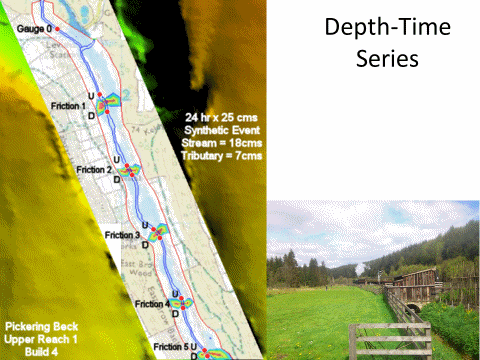
Click for frame by frame interpretation
Interim conclusions for further models
- Smooth ‘risk-contour-buffer-line’ points at QT50 and perimeter QT100 (national archive) Flood Map
- Buffer and resampled bank-points at 5m rather than 8m (relative to channel centre line)
- Harden solution convergence to 1% (rather than 5%)
Further research focus
- METHODOLOGY TEST at Pickering Beck Study Site (c.12km x 160ha)
- Extend 2km Levisham model to 12km discharging out of the model at Ropery Bridge gauge
- Decrease average channel width whilst maintaining bank-line point density; increase point density of floodplain ‘risk-contour-lines’; increase c/line resample from 16m to 8m
- Introduce high friction cross sections at 250m intervals and floodplain pinch-points to reduce/diffuse Ropery Bridge peak by 0.5m
- Increase complexity: point cloud from 2400 to 10000 nodes (ie 15 nodes/ha to 60 nodes/ha)
- FRM SOLUTION from River Elwy Study Site (c. 27km x 450ha)
- Progress ‘Pickering’ point cloud density to improve precision within horizon productivity goals (below); try 12000 – 24000 nodes (ie 25 nodes/Ha to 50 nodes/Ha)
- relate high friction features (here, here; here; here) to Elwy site field by field.
- Introduce high friction cross sections at 250m intervals and floodplain pinch-points to reduce/diffuse St Asaph bridge Q75 peak by 0.8m (ie reduce QT75 to QT25 levels)
- HORIZON GOALS
- Stream real event models in real time to compare low friction and high friction floodplain performance; 15 min time steps to be solved in approximately 4 minutes (ie real-time x 4)..
- .. ..
- Johnson’s Creek Attenuation Model before conclusion of 2013-2015 EPSRC Blue-Green City research programme (built on Oregon foundations)
..
End of content – only tiresome ads below
Keywords: Agristructure, Pickering Beck; Flood; Slow_the_Flow; STF; Forestry; Attenuation
![]()
———————————————–
Moderation (reducing complexity)
Posted: January 1, 2014 Filed under: Uncategorized Leave a comment
Back |
. |
Next |
The table below (yet under construction as legacy files are relisted) shows 2D calibration models for the inflow and outflow discharge conditions; also thereafter to assess the productivity of the finite element mesh derived from the assembled point cloud. In broad terms the complexity of the model is reduced to solve within the goal of 30,000 nodes in real time. The background to Levisham hydraulic analysis is here.
Reference OS & relief maps are here & here
| Model | km x km2 | In-Flow | Tributaries | Out-Flow | Graphic |
| pic4b2-steady | 12 x 1.0 | 3 @ 67.0 | 3121111 | Q = 0.07H ^2.1 | more .. |
| Q = 0.09H ^2.3 | |||||
| Q = 0.05H ^1.7 | |||||
| Q = 0.05H ^1.9 | |||||
| Q = 0.07H ^1.8 | |||||
| Q = 0.07H ^2.4 | |||||
| Q = 0.05H ^2.5 | |||||
| Q = 0.07H ^1.8 | |||||
- Model
- Spatial size
- In-flow discharge characteristics
- Tributaries
- Out-flow discharge relationship : H=stage; k & m parameters of flume equation Q = kH^m; weir equations within the range Q=0.04H^1.5, to Q=0.09H^2.5 viewed to be worth testing
Top
End of content – only tiresome ads below
![]()

